Super Typhoon Odette [Philippines] #OdettePH | Tropical Storm Rai | Weather Updates & Advisories
16 December 2021
BREAKING: Signal No. 4 is now raised over Dinagat Islands, Surigao del Norte, Southern Leyte, and the eastern portion of Bohol due to Typhoon #OdettePH, weather bureau PAGASA says. pic.twitter.com/osPjEQ97GU
— CNN Philippines (@cnnphilippines) December 16, 2021
15 December 2021 - The entire Negros Oriental and 15 other areas in the Visayas have been placed under Signal No. 1 due to the threat of Typhoon #OdettePH. 🌀
This is according to PAGASA's latest weather bulletin issued 11 a.m. Wednesday, Dec. 15, 2021.
Strong winds are expected within the next 36 hours in aras under Signal No. 1, PAGASA said.
Areas under Signal No. 1 in the Visayas are: Negros Oriental, Negros Occidental, Siquijor, Bohol, Cebu, Eastern Samar, Northern Samar, Samar, Leyte, Biliran, Southern Leyte, Iloilo, Capiz, Aklan, Antique, and Guimaras.
According to PAGASA's latest weather bulletin, heavy to intense with at times torrential rains are expected over Negros Oriental early morning tomorrow (Dec. 16) until early Friday morning, Dec. 17.
Based on the latest forecast track, Odette may make landfall over Negros Island on Thursday evening or early Friday morning.
 |
| LOOK: Deployable response groups (DRGs) and quick response teams (QRTs) of the Philippine Coast Guard (PCG) Station Negros Occidental are all-set for the conduct of evacuations and rescue operations amid severe tropical storm #OdettePH. |
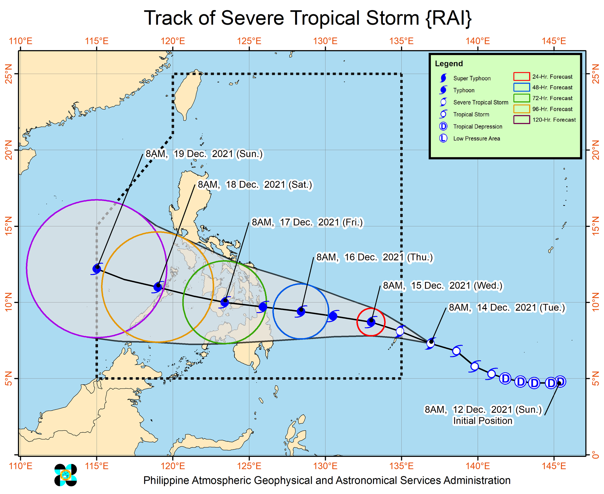
14 December 2021 - Tropical Storm Rai has intensified further into a Severe Tropical Storm, Pagasa announced on its 11 a.m. weather bulletin on Tuesday, December 14. Based on the state weather bureau's latest forecast track, it will enter the Philippine Area of Responsibility (PAR) between Tuesday afternoon and evening, and will make landfall within the vicinities of Caraga or Eastern Visayas by Thursday afternoon, December 16.
Pagasa also projects that Rai, which will be named Odette once it enters PAR, will pass through the southwestern town of Ronda, Cebu around 8 a.m. on Friday, December 17.
PUBLIC ADVISORY: TYPHOON ALERT
Issued at 11:00AM, 14 December 2021
Rai (Pre-Odette) intensifies into Severe Tropical Storm while moving west northwestward towards Palau.
TROPICAL CYCLONE STATUS:
• Location of Center (10:00 AM): The center of the Severe Tropical Storm was estimated at 1,165 km East of Mindanao (7.3°N, 136.4°E) (outside the PAR)
• Intensity: Maximum sustained winds of 95 km/h near the center, gustiness up to 115 km/h, and central pressure of 990 hPa
• Present Movement: West northwestward at 30 km/h
FORECAST OUTLOOK:
• Severe Tropical Storm Rai is forecast to enter the Philippine Area of Responsibility (PAR) as a severe tropical storm this afternoon or evening.
• This tropical cyclone is forecast to reach typhoon category on Wednesday. A pre-landfall peak intensity of around 155 km/h may be reached by Thursday morning or afternoon.
TROPICAL CYCLONE ADVISORY NO.6
Severe Tropical Storm "RAI"
Issued at 11:00AM, 14 December 2021
Valid for broadcast until the next advisory at 11:00PM today
“RAI” INTENSIFIES INTO SEVERE TROPICAL STORM WHILE MOVING WEST NORTHWESTWARD TOWARDS PALAU.
Location of Center (10:00 AM): The center of the Severe Tropical Storm “RAI” was estimated based on all available data at 1,165 km East of Mindanao (7.3°N, 136.4°E) (outside the PAR)
Intensity: Maximum sustained winds of 95 km/h near the center, gustiness up to 115 km/h, and central pressure of 990 hPa
Present Movement: West northwestward at 30 km/h
GENERAL OUTLOOK FOR THE FORECAST PERIOD
• Severe Tropical Storm “RAI” is forecast to move west northwestward while gradually intensifying and enter the Philippine Area of Responsibility (PAR) as a severe tropical storm this afternoon or evening. Once inside PAR, the domestic name “ODETTE” will be assigned to this tropical cyclone. “RAI” will begin moving westward over the Philippine Sea on Wednesday afternoon and may make landfall in the vicinity of Caraga or Eastern Visayas by Thursday (16 December) afternoon or evening. While inside the PAR, favorable atmospheric conditions will favor sustained intensification prior to landfall. This tropical cyclone is forecast to reach typhoon category on Wednesday. A pre-landfall peak intensity of around 155 km/h may be reached by Thursday morning or afternoon.
• There is a high likelihood that Tropical Cyclone Wind Signals will be hoisted for Visayas, large portions of Mindanao, and several provinces in Southern Luzon due to the threat of strong to typhoon-force winds associated with the passage of “RAI”. The highest possible wind signal that may be hoisted is TCWS #3. Localities situated in the eastern portions of Visayas and Mindanao may be placed under TCWS #1 as early as this afternoon or evening.
• In the next 24 hours, the trough of Severe Tropical Storm “RAI” will bring light to moderate with at times heavy rains over Caraga and Davao Oriental. The passage of this tropical cyclone over the central portion of the archipelago may bring heavy to torrential rainfall over Visayas, Mindanao, and several provinces in Southern Luzon, which may bring possible flooding and rain-induced landslides. Coastal inundation due to high waves near the coast and storm surge are also possible for low-lying localities near and along the path of the typhoon. Residents over the northern and eastern portions of Northern Luzon and the eastern portion of Central Luzon are also advised to monitor for updates regarding possible heavy rainfall which may occur in relation to the behavior of the shear line during and after the passage of this tropical cyclone.
• The passage of “RAI” will bring rough to high seas (reaching very high or phenomenal in open sea near the center of the cyclone) over the seaboards of Southern Luzon and Visayas, and the northern, eastern, and western seaboards of Mindanao. Rough to high seas are also possible for the seaboards of Northern and Central Luzon. Sea travel is risky for all types of seacrafts over these waters.
• Moderate to rough seas are also possible for the remaining seaboards of Mindanao during the passage. Sea travel is risky over these waters for small seacrafts.
Considering these developments, the public and disaster risk reduction and management offices concerned are advised to continue monitoring for updates related to this tropical cyclone.
Unless an intermediate advisory or initial tropical cyclone bulletin is released, the next tropical cyclone advisory will be issued at 11:00 PM today.
'STRONGER AND HAS MORE WATER.'
This was how Silliman University Earth Science professor Francisco Ablong Jr. described Severe Tropical Storm "Rai," which is now on its way to the country and soon to be named #OdettePH.
"Based on the latest available data, Typhoon Odette is STRONGER and HAS MORE WATER than the previous Typhoon Sendong last December 16, 2011," Ablong wrote, referring to the tropical storm that also struck Dumaguete City around this time ten years ago.
"What is much worrying here is the volume of rains Odette is carrying. The rain coverage of Odette is larger and wider compared to Sendong," Ablong added.
He also advised local distaster authorities and personnel to "seriously consider the threatening characteristics" of Severe Tropical Storm Odette.
Based on the latest PAGASA forecast track, Odette is expected to make landfall in Negros Oriental on Friday, December 17, 2021.
RDRRMC Memorandum
Cancellation of Land Travel Due to Tropical Depression "Odette" Outside of PAR
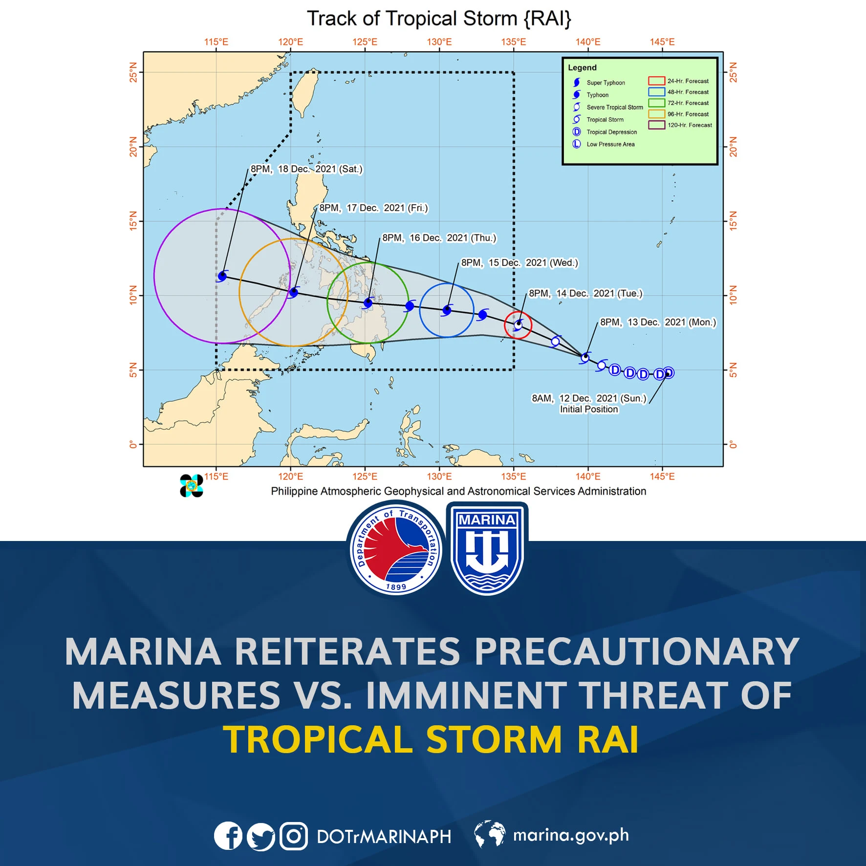
MARINA reiterates precautionary measures vs. imminent threat of Tropical Storm Rai
MANILA – The Maritime Industry Authority (MARINA), through its Advisory No. 2021-72, advises domestic shipowners and ship operators to observe the necessary precautionary measures in preparation for the possible inclement weather caused by Tropical Storm Rai, which will be known as Odette in the Philippines and is forecasted to enter the Philippine Area of Responsibility (PAR) later this week.
Shipowners are advised to monitor and comply with the weather announcements from the Philippine Atmospheric, Geophysical and Astronomical Service Administration (PAGASA) together with the Notices to Mariners issued daily by the NAMRIA and the Philippine Coast Guard relating to sea state and gale warnings.
Additionally, communication equipment should be always be observed closely to maintain safety and avoid disaster on board and at sea. All concerned entities must also ensure compliance with the Strict Implementation of Code of Safety Stowage and Securing in the Domestic Shipping.
Ships should not sail if the port of destination or areas of operations are affected by even the lowest signal of weather disturbance, and shipowners must ensure that their ships have been put to shelter without delay.
The MARINA also urged officers and crew members to be alert at all times. Preparation for abrupt changes in weather conditions is necessary as areas which may have been considered sheltered may quickly become exposed.
As the prompt dissemination information is imperative during typhoons and other weather disturbances, MARINA also advised that shipowners should follow the warnings and advice of the government forces stationed at the ports of the movement of vessels during the heavy weather.
Lastly, in areas or ports where there are no government regulators, all concerned should observe precautions and police their operations.

![Weather Updates & Advisories: Tropical Storm Rai - Typhoon Odette [Philippines] Weather Updates & Advisories: Tropical Storm Rai - Typhoon Odette [Philippines]](https://blogger.googleusercontent.com/img/a/AVvXsEgUb4VH7ee5ooZ8oQTw6jbRQNhXJW_vdoeejQlGbt9k50-8NI7Fg-dzVH_WE7KghWMTGUdL1_Mi1r0C_InV30FciJ6oCPCC_ITHQi4exmSGHRzrQmhkeWakTyhO42ItkzVsKLhEZTBoIhuQRAThOaBLg8QFWkyXQwIV6pG6NSwRerZiiwHGag=s16000-rw)


No comments:
Got Something to Say? Thoughts? Additional Information?